
http://www.suntimes.com/technology/guy/213451,CST-FIN-eCol17.article
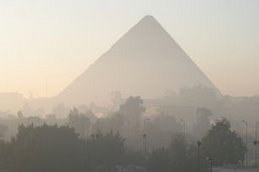
"The University of Chicago's Oriental Institute, known for antiquities scholarship, is using mapping software and spy-satellite photos to unravel the mysteries of how people lived, traveled and built civilizations. The results could reveal findings as diverse as an ancient Egyptian settlement flooded by a dam, the routes explorers took to settle in Chicago's Beverly neighborhood, and why Iraq is considered the cradle of civilization. . . . The project, called the Center for Ancient Middle Eastern Landscapes or CAMEL, uses geographical information systems (GIS), the same mapping technology as Google Earth, to pinpoint details of ancient sites and even date their origins. That's possible because GIS encompasses data and trends analysis, and the ability to look at the results on two- and three-dimensional maps. . . . The project is unique in archeology because it aims to keep ancient sites intact, rather than to disturb them by excavation."
See the above page for the full feature.
The Oriental Institute page dedicated to CAMEL is at:
http://oi.uchicago.edu/OI/PROJ/CAMEL/Main.html
No comments:
Post a Comment